A poor parish on the North Downs

 Edward Hasted visited Lyminge towards the end of the 18th Century when he was compiling his mammoth multi-volume History and Topographical Survey of the County of Kent, first published in successive volumes from 1778, with a second edition from 1797.  He had a rather poor view of the parish, noting that: 


‘the greatest part of it [is] on high ground, where it is a dreary and barren country of rough grounds, covered with woods, scrubby coppice, broom and the like, the soil being an unfertile red earth, with quantities of hard and sharp flint stones among it. In that part adjoining to the Stone-street way, is Westwood…and not far from it, two long commons…the one called Rhode, the other Stelling Minnis…there are numbers of houses and cottages built promiscuously on and about them, the inhabitants of which are as wild and in as rough a state as the country they dwell in.’


In a form of back-handed compliment, Hasted did concede that the land around the spring in Lyminge was ‘far from unpleasant’, and he noted that the land of the valley bottom around the course of the Nail Bourne was fertile with good meadows. This was where the majority of the population was focused.


Hasteds map of Loningborough Hundred 
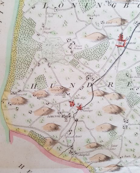
Detail from Hasted's map of the administrative districts of Loningborough and Folkestone Hundreds, showing the area of Lyminge c1778  (©Rob Baldwin)


After almost 1,000 years as a church estate, Archbishop Cranmer surrendered the manor of Lyminge to King Henry VIII in 1547. It then passed through the hands of a series of secular absentee landlords who seem to have taken little interest in the place, being content it seems to take the rents and leave it be. Without a wealthy family resident in the parish, there was no great house and the church remained plain and unadorned. In 1588 there were 283 communicants, and in 1640, there were 255, representing a total population of perhaps around 400. In the census of 1801, there were still only about 420 people in Lyminge (although it is difficult to be precise as the return included the neighbouring parish of Stelling). Aside from the few artisans like the blacksmith and the carpenter who provided the skills to make and mend tools and equipment, the majority of the local population worked the land. It is difficult to say that Lyminge even existed as a village because the habitation across the parish comprised a scatter of farmsteads, each with a group of cottages close by where the farm workers lived. This created a patchwork of hamlets, which to some extent are still visible today. On the road from Etchinghill to Lyminge, for example is the hamlet of Broadstreet, where the farmhouse was rebuilt in the early 19th Century but the farm cottages still stand on the opposite side of the road. Bedingfield in the High Street is an old timber-frame farmhouse, though now encased in brick. It was once Yard Farm, and still stands across the road from cottages of a similar date.  Old Robus is a fine 16th Century house, with later additions, still standing in Canterbury Road, but the cottages that supported the farm have long-since been demolished.


Old RobusOld Robus, Canterbury Road c1903 (©Rob Baldwin)

BedingfieldYard Farm in the High Street, now known as Bedingfield, in the early 1900s (©Lyminge Historical Society)


In essence, the community can hardly have changed over these centuries. From time to time, farmhouses were rebuilt or added to and improved in the fashion of the time, but farm cottages remained dark and insanitary. Work in the fields was hard, and from the account of Edward Hasted, was particularly difficult outside the valley bottom. The scattered houses built at Rhodes Minnis were essentially smallholdings carved out of the common land that still survived in this part of the parish. Some 9 acres of the common were enclosed in 1819.  The common here was finally fully enclosed in 1855, although the Inclosure Commissioners did at the same time set aside 4 acres for a parish recreation ground and 4 acres for allotments 'for the labouring poor'.  These plots are still owned and managed by the Parish Council.  Life on this difficult ground would have been hard and was pretty much at subsistence level.


In the tithe survey of 1840, one of the largest landowners is recorded as the Rector, Ralph Price, who held land both as Rector and Vicar, and much more in addition in his own name. It was the Rector who was Lord of the Manor, and he was a significant force in this small community as his flock extended quite literally across the fields and the cottages of the parish. It was a small-scale inward looking community, relying largely on its own resources, and holding just a single annual fair. In many ways it was far less connected with the outside world than it had been when Queen Ethelburga founded her church 1,200 years before. But although this agricultural way of life may have seemed timeless and as if it would last for ever, that was not to be, and much was to change in the following decades.  


Church, Forge and Coach and HorsesThe economic heart of Lyminge until the later 19th Century.  This view c1910 shows the forge foreground right, opposite the pub The Coach and Horses, rebuilt on the site of an earlier pub in 1888.  The village school between the forge and the church was built in 1849, on the site of an earlier school.  The schoolmaster's house is opposite the school.  Behind this but not visible in the photo, in what is now Well House, was the village shop in 1840, which by 1871 had diversified into a grocer, bakery and beershop called "The Grocer's Arms" in the census of that year(©Rob Baldwin)

Mill Cottages at Yew Tree CrossMill Cottages and Windmill at Yew Tree Cross c1907  (©Rob Baldwin)


Sheep on Tayne Field c1960Sheep grazing on Tayne Field c1960, showing how central parts of the village remained very rural well into the 20th Century  (©Rob Baldwin)


This page is managed by Lyminge Parish Council Historic Environment Working Group